We’ve visited a few lost highways before, like this one in Minnesota, or this flooded road near Devils Lake, but in my opinion, this is the most significant lost highway in the state of North Dakota, for reasons I’ll explain below.
While there are many reasons a highway becomes lost — rerouting of the road, mining, and freeway construction, for example — this road fell victim to the greatest flood in North Dakota history, a man-made flood, and now, this lost highway leads to the bottom of a lake.

About three miles north of Twin Buttes, North Dakota, on the Fort Berthold Reservation in Dunn County, Highway 8 becomes a dead end at the point shown above. In the upper left you can see Lake Sakakawea in the distance, the reservoir which forced the abandonment of this highway. There was an area on the left where we could see previous visitors had been driving around the barricades, but we chose to park here and hike the mile to the bottom.

Just a little further down the road, a second set of barricades were set up on a narrow stretch of the road, and you can’t drive around them, so we didn’t regret the choice to set out on foot.


The appearance of the road changed with the grade. In places where the grade was a little steeper, the remains of the road were plainly visible, with weeds and prairie flowers growing up between the cracks in the heavily weathered surface.
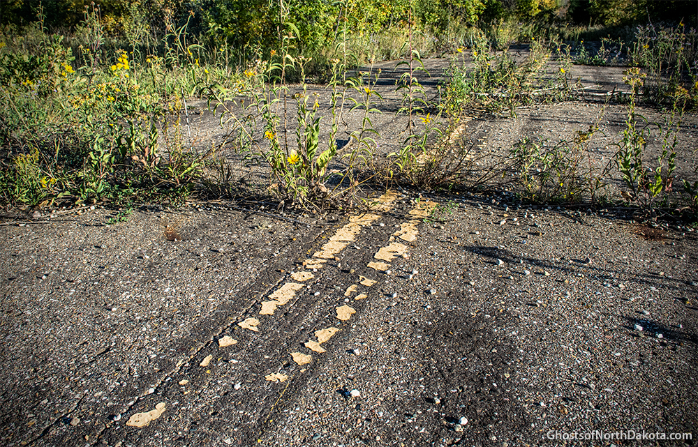
In other places, where the grade flattens out a bit, runoff sediment from the hills above has been settling for decades, obscuring the asphalt surface beneath a carpet of gravel and overgrowth.


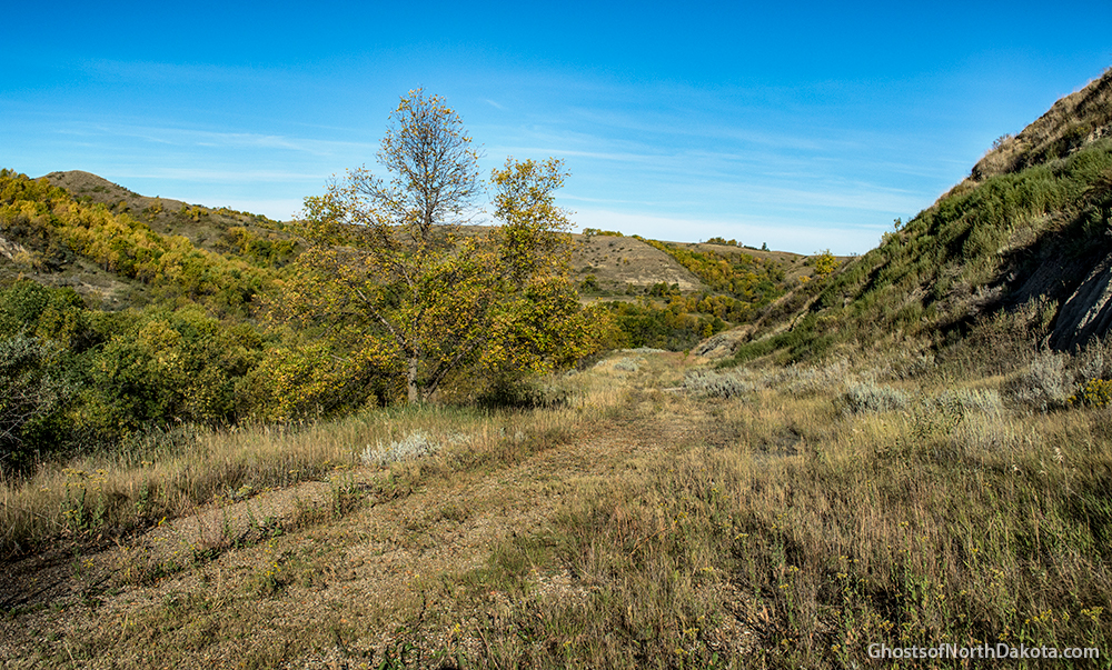
The road traces a path down the side of a butte and the scenery is absolutely amazing.


Just as we found ourselves distracted by the amazing scenery and feeling like we were on a nature hike, we were reminded that cars used to travel the road on which we were standing at highway speeds.

The road parallels a deep ravine to the west, and there were no remnants of guard rails at any point along the road that we could see. Apparently, there was nothing to keep an inattentive driver from a quick trip to the bottom. Whether this rusted old wagon ended up at the bottom of the ravine in a tragic accident or was simply dumped, we don’t know, but aerial imagery shows it has been there for decades.


In one spot, a section of the highway slides away from the rest due to a minor landslide in which a portion of the hillside has separated and started to creep downhill.


Above: As we neared the bottom, we found a section of the road where someone had burned a bunch of old tires.

About a mile down the road, we finally arrived at what is today the bottom. This lost highway originally would have continued down into the Missouri River Valley, but today that valley is full of water and this is the end of the line. In the photo above, the water is a small bay of Lake Sakakawea (I’m not sure if it has a name, but Mandan Bay is just a few miles west) and the water is a little lower than average.

Beyond the end of the asphalt highway, small pieces of asphalt, weathered and broken down from runoff and fluctuating lake levels that bring periodic inundation, litter the prairie grass.

Someone made the trek to the bottom for a bonfire and a couple beers.

So, where did this highway go? It went down into the valley where the water is shown in the photo above, and it would have curved to the right around the point in the upper right of the photo, where the bulk of Lake Sakakawea is today. The highway led to the town of Elbowoods and the Four Bears Bridge, which was the only crossing over America’s longest river, the mighty Missouri, for miles around.
In 1953, Garrison Dam was completed, and the Missouri River Valley became a reservoir, or Lake Sakakawea. In one of the great injustices of modern times, the Three Affiliated Tribes lost 94% of their agricultural land, as detailed by author Michael Lawson in his book “Dammed Indians: the Pick-Sloan Plan and the Missouri River Sioux”.
The Four Bears Bridge was floated upriver and re-erected with new approach spans near Crow Flies High Butte. The communities of Elbowoods, Van Hook, Independence, Sanish, and others were forcibly evacuated and disappeared beneath the waves.
In addition to the evacuation of the towns which once stood in the valley, the Garrison Dam contributed to the abandonment of farms and towns even on high ground by cutting off transportation routes between the northern and southern portions of the state. Where you once would have been able to cross the Missouri River here and visit someone on the other side in just a few minutes, the drive is now an hour or more in many places due to the size of the lake and the required drive around the east or west ends.
There are few remnants today of the pre-Garrison Dam era, but this lost highway is one of them, and we’re glad we got to visit.

Above: Looking back from the end of the road, as we prepared to hike a mile uphill. We got our exercise this day.
What do you know about this old highway, Four Bears Bridge, and Elbowoods, North Dakota? Leave a comment below.
Photos by Troy Larson and Terry Hinnenkamp, © Sonic Tremor Media

i believe in the 70’s there used to be a ferry that ran across sakakawea at that location.
LikeLike
Did this Hwy 8 connect with Hwy 8 in Mountrail Co thru Van Hook???
LikeLike
Look on google earth and you can see the old road bed on the north side of the lake. meets up with 1804 at the corner where it turns from east-west to north-south. the other end of the ferry was in elbowoods bay.
LikeLike
I saw that too, AJ. Interesting that the southern end appears to have been paved, but the north end shows no signs of asphalt.
LikeLike
Great post! Thank you.
LikeLike
Was the town of Sanish near here?
LikeLike
Vernese, Sanish was about 35 miles to the northwest.
LikeLike
great photos, how sad that a time to make progress, has lost much of its natural beauty, what a scenic route this would be if there was a bridge to connect it to the other side
LikeLike
LikeLike
An interesting look at the new Four Bears Bridge, Daro. Thanks for posting it! For the sake of clarity, the Four Bears Bridge referenced in this post was the old Four Bears Bridge, which was demolished a few years back.
LikeLike
From looking at the station wagon, it was made in the early to mid 1970s by General Motors. My guess is it’s mostly likely a Chevrolet.
LikeLike
I was trying to figure it out too… At first I thought it was a Pontiac Catalina?
LikeLike
Very cool story. I worked in the ND oilfield from ’09-’13. Hauled sooo much of that awesome Bakken Sweet Light Crude. I miss it. I also miss standing on top of the tank walkway overlooking the Van Hook Arm. Many, many hours sitting in the cold, sun beaming down on the lake and surrounding fields of snow, very nice. I’ve driven past the north connector of Hwy 8 where it meets Hwy 1804 many times and never knew. To me it was just another road into another field.
I’m not from North Dakota, or even from the US, but having worked in the area for four year, I’ve developed an affinity for the area after becoming familiar with the North West corner of the state. It brings back some great memories.
Keep up the good work and the great stories!
LikeLike
A very dear friend of mine dead now for several years who by the way lived to be 99 and 3/4 she hoped to make it to 100) was born in Sanish lived there until married and moved to Fargo!!!
LikeLike
What we know about this part of history would fill a book with alot of memories. Brings back alot of sadness in the loss of many things when the river bottoms were flooded by the Dam.
LikeLike
Read the book! CADILLAC DESERT you will understand the damming of our country.
LikeLike
What a neat place. Great writeup!
LikeLike
My Great Uncle taught school int Elbow Woods for many years. Also, my grandparents house which still stands in Garrison was moved down from Sanish when the town was going to be flooded.
LikeLike